Use of photogrammetry for documentation in car accidents
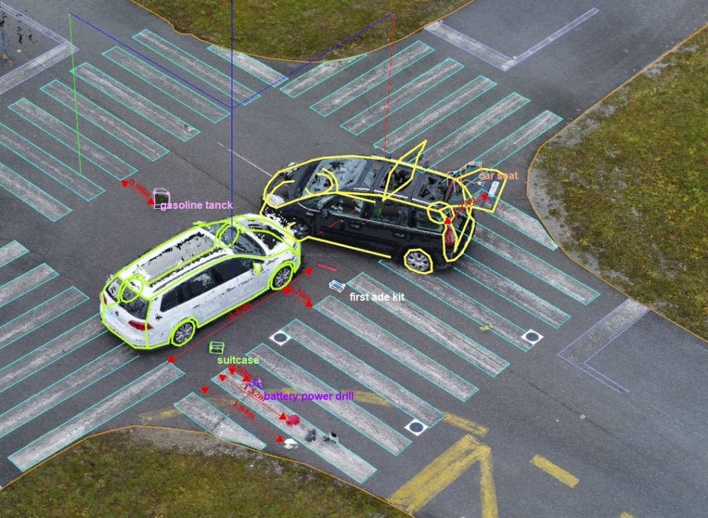
When a road accident occurs, authorities must close the road to traffic, sometimes for hours at a time, because they need to ensure that safety is restored, but they must also investigate the scene of the accident to determine why and how the accident occurred, which can take hours. This not only affects the people […]
Drone photogrammetry in environmental issues

Photogrammetry is a data collection and analysis technique that is becoming increasingly important in the field of environmental disasters in Romania. In such situations, an accurate and rapid assessment of environmental impacts and public health risks is required and photogrammetry can be of great help in this respect. Floods and landslides In the case of […]
The role of 3D facade and building scanning

The 3D facade and building scanning service is a modern technology that can provide valuable information to architects or engineers about the structure and current condition of a building. This information can be particularly useful for people who have just bought a house or want to build a new one. This 3D scanning service of […]
3D scanning surveys

Nowadays, 3D building surveys are becoming increasingly popular and are replacing traditional designs by architects or surveyors for building extensions or construction, as well as fire evacuation plans. This modern technique is much faster and more efficient, allowing architects to save time and focus on other important tasks, given that time is limited. However, the […]
How does 3D scanning work?

3D scanning can be one way to start a 3D printing project. The construction of a three-dimensional representation of an object can be done by 3D modelling software or by 3D scanning. 3D scanning is the process of analysing an object in reality to collect all its information and recreate its appearance and shape in […]
Benefits of 3D scanning

More complex surveying projects include 3D scanning with a specialised laser. To measure distances and very precise locations they use laser light and a special radar. Even from great distances, measurements can be made and digital images can be obtained, which can be included in architectural and construction projects. Project managers and engineers who monitor […]
Aerial photogrammetry, a modern and efficient measurement method

New technologies make the present and the future “sound good” in terms of cadastre and topography. Today, companies operating in this sector, for example Ecad for example, have the latest generation of devices, which can be used to take centimetre-by-centimetre measurements, which are very useful when studying land or buildings. Individuals, legal entities, organisations, associations […]
What can a land registry firm do for you?

Not many people know exactly what land registration entails and why so much important paperwork is needed when they want to sell, buy or exchange their home. Well, in a broad sense, cadastre refers to the identification and measurement of a property. Whether it’s an apartment, land or a house, this must be done before […]
Topographical surveys: what do they mean and why are they useful?

Every construction project needs professionals, who offer specialised services, to develop it correctly and safely. This type of service also includes topographical services, which are designed to analyse the land and soil so that construction can take place on a safe basis that will not cause damage or even disaster after the passage of time. […]
How can the strength structure of a road bridge be checked?

Romania’s road infrastructure is a sensitive subject, especially for drivers, as it is quite poor. This is due both to the poor state of much of the country’s roads and to the fact that the area of newly built roads is extremely small, despite technological developments. However, safety always comes first, which is why many […]