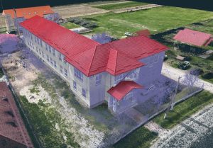
• 3D Scanning, Surveying and Orthoimages
• We work with architects, designers and developers to deliver accurate documentation with fast turnaround.
• We use state-of-the-art equipment to ensure results meet professional planning standards.
We performed a detailed 3D scan of a large disused building located in Mioveni, Argeș, to be modernized. The project involved several stages, starting with the processing of the 3D scan data and inputting it into the Stereo 70 coordinate system, so that it could be used to update the cadastre of the area. We also carried out the surveys for the ground floor, first floor and attic, and used PointCab software to generate the necessary documentation for the visualization and analysis of the plans. This work is essential for preparing the permit documentation and preparing the building for modernization.
We offer free advice!
© Copyright 2023 3DMaps