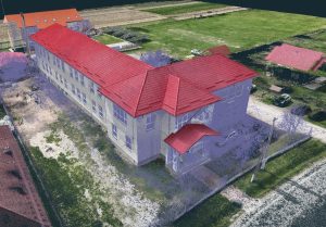
“3D model of the site from point cloud + proposed block volumetry. Used at City Hall for urban integration, setback/elevation verification and public presentation.”
We performed the photogrammetric survey and delivered the georeferenced (RGB) point cloud of the area.
The architectural firm inserted the volumetry of the proposed building into the model and generated the visualizations/photo montages.
City evaluated urban integration (CTATU/chief architect), verification of alignment, setbacks and heights in relation to neighborhoods, public presentation in the approval/authorization procedure.