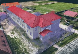
The school building was fully documented through 3D scanning with a GeoSLAM Horizon and aerial photogrammetry with a DJI Mavic 3 Enterprise, to produce measured drawings, the orthophoto plan, and georeferenced point clouds of both the interior and exterior.
Project Overview – 3D Scanning of a Rural School (Building Rehabilitation)
Project Objective
Rehabilitating a school building in a rural locality required precise technical documentation that reflects both the true geometry of the building and the current condition of its facades and interior. To achieve this, we used modern 3D laser scanning and aerial photogrammetry, aiming to obtain a complete, georeferenced model of the structure.
Stage 1 – Field Data Acquisition
Terrestrial 3D scanning
-
Equipment: GeoSLAM Horizon mobile scanner, enabling rapid capture of high-density point clouds indoors and outdoors.
-
Acquisition time: approx. 2 hours for interior + exterior.
-
Mean accuracy: 1–2 cm.
-
Raw data saved in ZEB Revo/Horizon format for subsequent processing.
Aerial photogrammetry with DJI Mavic 3 Enterprise
-
Automated flight with 80/70 overlap.
-
Altitude: 40–50 m.
-
Images calibrated and georeferenced using GNSS RTK.
-
Purpose: to obtain an accurate orthophoto background for the facades and the site conditions.
Stage 2 – Data Processing
Point-cloud registration and georeferencing
-
Interior–exterior clouds aligned in GeoSLAM Connect.
-
Clouds georeferenced to the national Stereographic 1970 system (Stereo 70) using GNSS control points measured on site.
-
Exported to .E57 and .LAS for use in CAD and BIM software.
Photogrammetric processing and orthophoto
-
Drone imagery processed in Agisoft Metashape / DJI Terra, resulting in a site orthophoto and textured 3D facade models.
-
Orthophotos were rectified and aligned to the 3D point cloud for a perfect match between field data and imagery.
Stage 3 – Plan Extraction and Vectorization
From the georeferenced point clouds, using PointCab we extracted:
These deliverables were then vectorized in BricsCAD, producing compliant 2D plans ready for technical design.
Stage 4 – Delivery to the Client
Delivery was made in digital format, structured into thematic folders:
3D point clouds
Orthophotos and photogrammetric models
Vectorized 2D plans (DWG/DXF)
Results and Benefits
By integrating mobile LiDAR and aerial photogrammetry, we obtained complete, accurate, and coherent documentation that gives the designer a solid basis for:
-
Assessing the condition of the building.
-
Correctly sizing structural and architectural elements.
-
Designing consolidation and rehabilitation interventions.
The total execution time (field + office) was significantly reduced compared to traditional methods, while delivering high accuracy and a photorealistic representation of the asset.