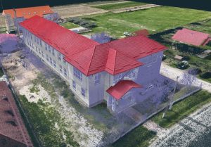
3D topographic and orthophoto plan from topographic drone in

Recent projects

Contact us

Project details

Project objective

Topographical survey for residential project

Customer

Natural person

Location

Com. Ratesti, jud. Arges

Project date

17 October 2021

Services

Execution of 3D topographic survey, 3D model, mesh, contour lines, orthophoto plan

Data acquisition

For this project we used a topographic drone, rtk gps to obtain the information from the field and photogrammetry software for data processing, which took 2 hours. The result was a 3D model (mesh), an orthophoto plan at 1.5cm resolution, contour lines and topographic survey, which was handed over to the architect.

Results

The data processing was done in a few hours resulting in orthophotos in .tiff format, 3d point cloud, which we processed in specialized 3d software plus 2D cad software.