3D scanning and photogrammetry for the 4 ha area in Sinaia, Prahova, for the construction of architecturally and urbanistically integrated blocks

Recent projects

Contact us

Project details

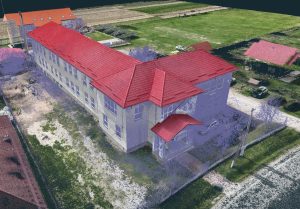
We realized the 3D scanning and photogrammetry for an area of 4 ha located in Sinaia, Prahova, destined for the construction of several blocks that will integrate architecturally and urbanistically the area. The work included 3D topographic surveying with details such as contour lines, vegetation, existing infrastructure, hydrography, accessibility, elevations, cadastral information, pillars and street details, plus point cloud and orthophotoplan.

Project objective

3D scanning and photogrammetry for building blocks

Customer

Legal entity

Location

Sinaia / Prahova

Project date

February 2024

Services

We realized a detailed 3D scanning and photogrammetry for a 4 ha area located in Sinaia, Prahova, where a group of blocks of flats will be built, which must be architecturally and urbanistically integrated in the landscape of the studied area. At the request of the architectural firm, the topographic survey was carried out in 3D format and included a series of details essential for the development of the project. These included contour contours, terrain details (such as vegetation and natural features), existing buildings and infrastructure (roads, fences, buildings), hydrography (watercourses and lakes), accessibility (roads and other access routes), elevations and elevations (including roof elevations of neighboring buildings), cadastral information (property boundaries and other relevant data), poles (electrical and infrastructure support), and details of ditches, culverts and canals. In addition, we have provided the point cloud and orthophoto map for a complete visualization of the terrain.