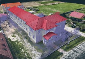
• 3D Scanning, Surveying and Orthoimages
• We work with architects, designers and developers to deliver accurate documentation with fast turnaround.
• We use state-of-the-art equipment to ensure results meet professional planning standards.
The process began with a detailed terrain assessment using advanced 3D scanning technology and RTK drones. Using a mobile scanner and drones, we generated a geo-referenced colour point cloud, providing accurate data for efficient planning of service housing construction.
1. Cloud of colour dots and ground mesh
Through photogrammetry and 3D scanning, we generated a colour point cloud and a detailed mesh of the terrain, highlighting the specific features and topographical peculiarities of the area.
2. Orthofotoplan
We developed a detailed orthophoto plan, providing a clear overview of the planned site and facilities, helping to optimise construction planning.
3. Topographical survey
By applying advanced technology and providing the necessary data for construction, we aim to contribute to the development of an infrastructure that meets the needs of the community, thus facilitating the start of the design and construction of quality service housing.
We offer free advice!
© Copyright 2023 3DMaps