3D land scanning and modelling, holiday home

• 3D Scanning, Surveying and Orthoimages

• We work with architects, designers and developers to deliver accurate documentation with fast turnaround.

• We use state-of-the-art equipment to ensure results meet professional planning standards.

Recent projects

Contact us

Project details

This case focuses on 3D methodology for producing accurate geographical data that can be used to update or regularise existing cadastral data.

The fusion of spatial technologies such as 3D scanning and the emergence of affordable platforms to process these technologies has opened up new opportunities for mapping and modelling land and cadastral boundaries. High resolution imagery can now be used to optimise the amount of data collected from the field and provides a more efficient and richer solution to define the area under study.

Data acquisition

This small area of land 2700sqm required a 30 min 3D measurement. To ensure accuracy of 1-4 cm we used 4 RTK GPS points for further post-processing and error assessment.

The amount and level of data detail we were able to acquire in 30 min was superb and far greater than was ever possible before 3D measurements were taken.

Results

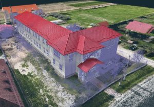
Image processing was done using specialised 3D software. GPS points determined in the field were used to generate a dense 3D point cloud georeferenced in the national reference system “Stereo 70”.

The measurement was carried out in winter and the resolution and quality of the results far exceeded the customer’s requirements.

The following results were provided: a digital surface model (DSM), a digital terrain model (DTM) by removing above-ground obstacles such as trees, georeferenced, in realistic colours, a height map, contour lines with 10cm equidistance and cross-sectional profiles. All this was done using 3D scanning. All data was exported to CAD for use by the architectural office.