Volumetric calculation 3D model

Recent projects

Contact us

Project details

This case focuses on the 3D methodology for producing accurate geographical data for the volumetric calculation requested by the beneficiary.

Project objective

Customer

Legal entity

Location

Jud. Argeș

Project date

14 October 2019

Services

Volumetric calculation / 3D model / Orthophoto plan with real situation

Data acquisition

This 5000sqm study area required a 30min 3D measurement. To ensure accuracy of 1-4 cm we used 6 RTK GPS points for further post-processing and error assessment.

Results

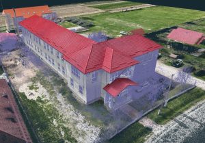
Image processing was done using specialised 3D software. GPS points determined in the field were used to generate a dense 3D point cloud georeferenced in the national reference system “Stereo 70”.

The following results were provided: a 3D model, georeferenced orthophoto plan, topographic survey with contour lines with 0.5m equidistance.